General Inquiry

Genasys | EMERGENCY MANAGEMENT
Accelerate response coordination and keep everyone informed.
Genasys unifies your communications, situational awareness, and cross-agency coordination into one operating picture. Whether managing a planned public event or a multi-jurisdictional wildfire, give your team the confidence of using the same proven tools every single day. Say goodbye to using tools that only do some of what you need, leaving the public to still call operators with questions, and start using Genasys: the integrated software and hardware communication solution built for all-hazard response and daily operational control.
Communicate Clearer, in Every Situation.

Intelligent Zones
Stop relying on static maps . Create and edit data-driven zones in real-time for daily needs like road closures or festivals. When an emergency happens, you are ready with hyper-precise message targeting on a public map.

Cross-Agency Collaboration
Eliminate jurisdictional silos with a map-based common operating picture that connects you seamlessly with Police, Fire, and neighboring counties for routine planning or complex mutual aid.

Risk Assessment and Planning
Plan effective emergency responses and evacuations by modelling “what if” scenarios. Stay a step ahead during ongoing emergencies with detailed emergency and evacuation simulations.

Multi-Channel Alerting
Send alerts to individuals, groups, or everyone in a geographic area through multiple channels: SMS, Genasys Acoustics, social media, voice calls, radio, digital signage, and more. Use LRADs on vehicles to target voice messages in emergencies.

“This solution enhances the public’s understanding of evacuation orders with an accessible map, additional messaging support, and locations of evacuation sites, shelters, and road closures. It also provides valuable operational decision-making support for first responders, offering detailed data on critical evacuation sites, fire modeling, and evacuation routes.”
Michael Chard
Director of the Office of Disaster Management, City of Boulder & Boulder County, CO








Genasys: The Communications Solution for Emergency Management
Enhance disaster preparedness and response coordination through accelerated data-driven decision making and cross-agency collaboration. Keep the public informed and ready at all times providing clear direction during evacuations, shelter-in-place orders, and repopulation procedures.
Genasys Protect
Target the right people with flexible, customized, and intelligent zones. Enhance decision-making through situational awareness accessible on the map. Collaborate internally and across agencies through a common operating picture. Send mutli-channel alerts to reach the public when it matters. Provide constant situational awareness for civilians through the mobile app and webpage.
Genasys Evertel
Collaborate and share information through real-time two-way chat. Maintain compliance with the strictest public safety security requirements and regulations. Collaborate internally, across regions, and with external organizations through virtual EOCs.
Genasys Acoustics and LRAD
Broadcast clear and intelligible alerts across long distances, over loud background noise and into buildings. Broadcast pre-recorded and live voice messages with information and instructions for citizens. Maintain communication even when power or satellite connectivity is lost. Reach vulnerable populations such as those with disabilities and the unhoused.

Genasys Protect | emergency management
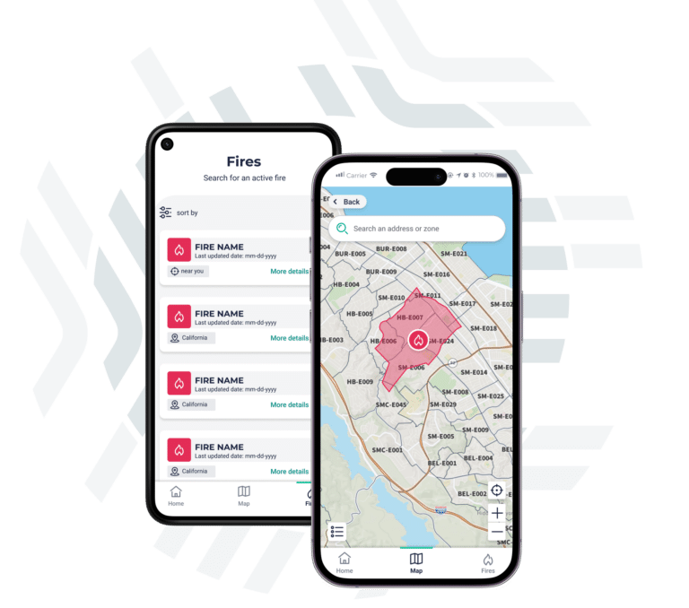
Download the Genasys Protect Mobile App
With the Genasys Protect mobile app, keep track of critical information that matters to your mutual aid partners, residents, and visitors. Additionally, users can choose to activate location services to receive alerts and safety instructions when they enter an area that is under threat. Learn more here, or download from the app stores below.


Genasys Partner Network
Extend your reach and impact with the leading solution provider in public safety. Being part of a strong public safety ecosystem allows us all to extend our solutions and services to ensure organizations and public safety agencies are ’Ready When it Matters.”™